Frisanco - Tour Itinerary

Mountain
GENERAL INFORMATION
LAST INSPECTION DATE
18/08/2022
PLANNED ITINERARY
Frisanco - Tour Itinerary
LENGTH
300 meters
DEPARTURE
Multi-storey car park Father Mauro d'Aviano
The itinerary unfolds in an urban area without tactile foot markers.
The tour can take place at any time of the year.
It is recommended to start the itinerary from Piazza XX Settembre, Poffabro's main square (Photograph 1) where there are six parking spaces, one of which is reserved for people with disability, measuring 2.40 x 4.40 metres, which is clearly identified with horizontal and vertical markers. The paving of the square is in mixed stone (piasentina and porphyry) in irregular sections with large, cemented joints and different slope gradients.
Atternatively, the covered “Padre Mauro d'Aviano“ smooth concrete multi-storey car park can be used (Photograph 2). Here there is a parking space reserved for people with disability measuring 4.90 x 3.00 metres, marked by horizontal markings on the ground, but without vertical signage. From the covered multi-storey car park, the following are present: a driveway ramp, with a slope of 18%, leading to the upper level (car park roof), with no separation and/or indication for the pedestrian itinerary; a staircase with handrail leading to Piazza XX Settembre.
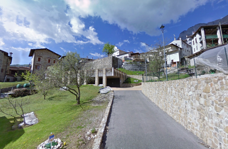
Photo 1
Photo 2

Photo 3
The former Cheese Factory, which now serves as the Infopoint - Poffabro Visitor Centre, is located in the centre of the square and is accessible using a ramp with a 7% slope, made of piasentina stone, uniform surface, 1.50 metres in width and 2.00 metres in length (Photographs 3 and 4). The Infopoint's areas are spacious and the flooring is made of uniform piasentina stone. A lift leads to the upper floor, with hardwood flooring, where there is a sanitary facility accessible to people with mobility disabilities. The Infopoint provides materials on the village of Poffabro (information pamphlet) and the Friulian Dolomites Natural Park. Please check the opening days and times.

Photo 4

Photo 5
Continuing to the left, there is the Church dedicated to Saint Nicholas. To reach the Church from the visitors' centre, it is necessary to cross the square (stone slab surface) and continue in front of the main entrance steps (porphyry slab surface similar to the car park in the square) and immediately take the uphill ramp to the right to access the side entrance. The ramp is 3.20 metres in width and 15 metres in length, divided into two sections: the first section with a 13% slope and the second section with an 8.5% slope (Photograph 5), and it does not have a handrail. The side entrance to the Church is accessible by means of an additional ramp, made of stone, without colour contrast, with a uniform surface measuring 1.50 metres in width and a slope of 8%, which allows the existing step of 18 centimetres to be bridged (Photograph 6). The main entrance to the Church has a flight of 6 steps ( Photograph 7).
Leaving the Visitors' Centre and continuing to the right (Photograph 8), past the square and approximately ten metres along the road (where there is no pavement), which is paved in stone with wide cemented joints and an average slope of 13%, is where Le Monde Café is located. To access the drinking area outside the café, it is necessary to overcome a step measuring 14 centimetres in height and to enter the premises, it is necessary to overcome another step measuring 9 centimetres.
Photo 6

Photo 7
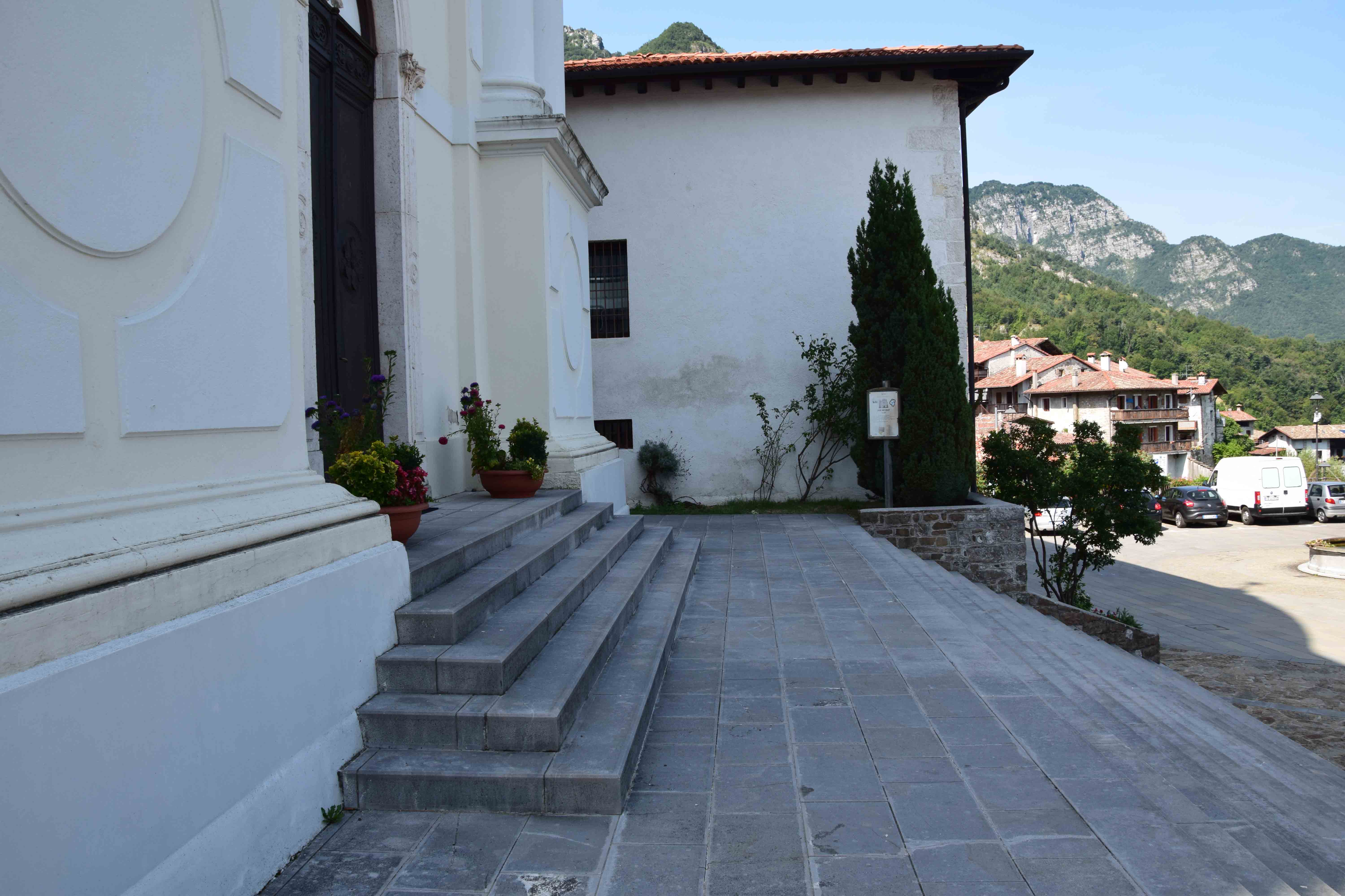
Photo 8
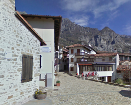
Photo 9
Please note that the itinerary for visiting the village consists of a tour of the village itself with access to the inner courtyards. This is achieved by climbing steps or steep slopes that are difficult to travel with ease for people with mobility disabilities or people who are also senior citizens.
The tour of the village continues uphill along via Antonio Villanova (visitors encounter a crossroads between Via Villanova and Via Voul), the surface is stone, as described previously, with an average slope of 13%. The road features widening and narrowing, depending on the conformation of the buildings. The narrowest point that was surveyed measures 2.20 metres. Subsequently, there is a section with a constant slope of 11% and another with a slope of 16%. Moving forward, there is a small square that leads to the right along Via Fisar, which is first a flat section (stone paving as described previously) followed by significant downhill sections. Opposite, however, is a building with an arched portico that introduces, along an uphill stretch, the group of internal courtyards of Via Giacomelli.
Continuing along Via Villanova at street number 14, an exhibition of Scarpeti handicrafts is located; here too, the itinerary proceeds using an uphill entrance hall that opens up to an inner courtyard framed by two blocks of houses, one of which, on the ground floor, houses the handicraft exhibition. The itinerary has a 20% slope.
Shortly afterwards is the intersection of Via Taviele and Via Di Caterina and a votive altarpiece dedicated to the Virgin Mary. Via Taviele begins with an uphill itinerary with a constant slope, while Via Di Caterina begins with a flight of steps. Shortly afterwards, Via Voul begins with a downhill ramp with a slope of 13% and a width of the road, paved as previously described, of 2.00 metres (Photograph 9).
Continuing along the itinerary, visitors arrive at a small square with a wooden bench and fountain, formed by the intersection with Via Bertoli, the latter consisting of a flight of uphill steps. The end of Via Voul coincides with the beginning of Via Villanova (Photograph 10).
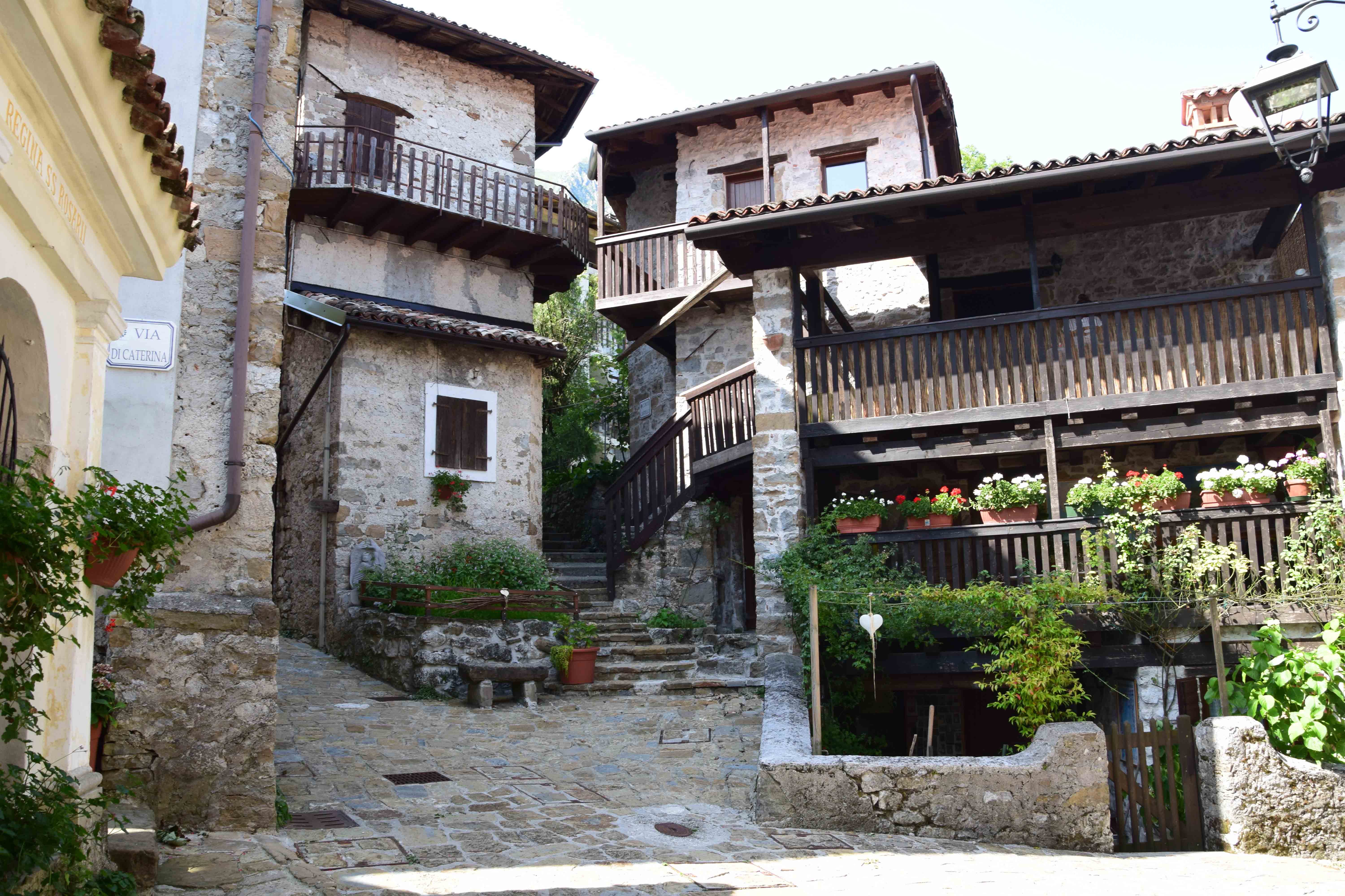
Photo 9
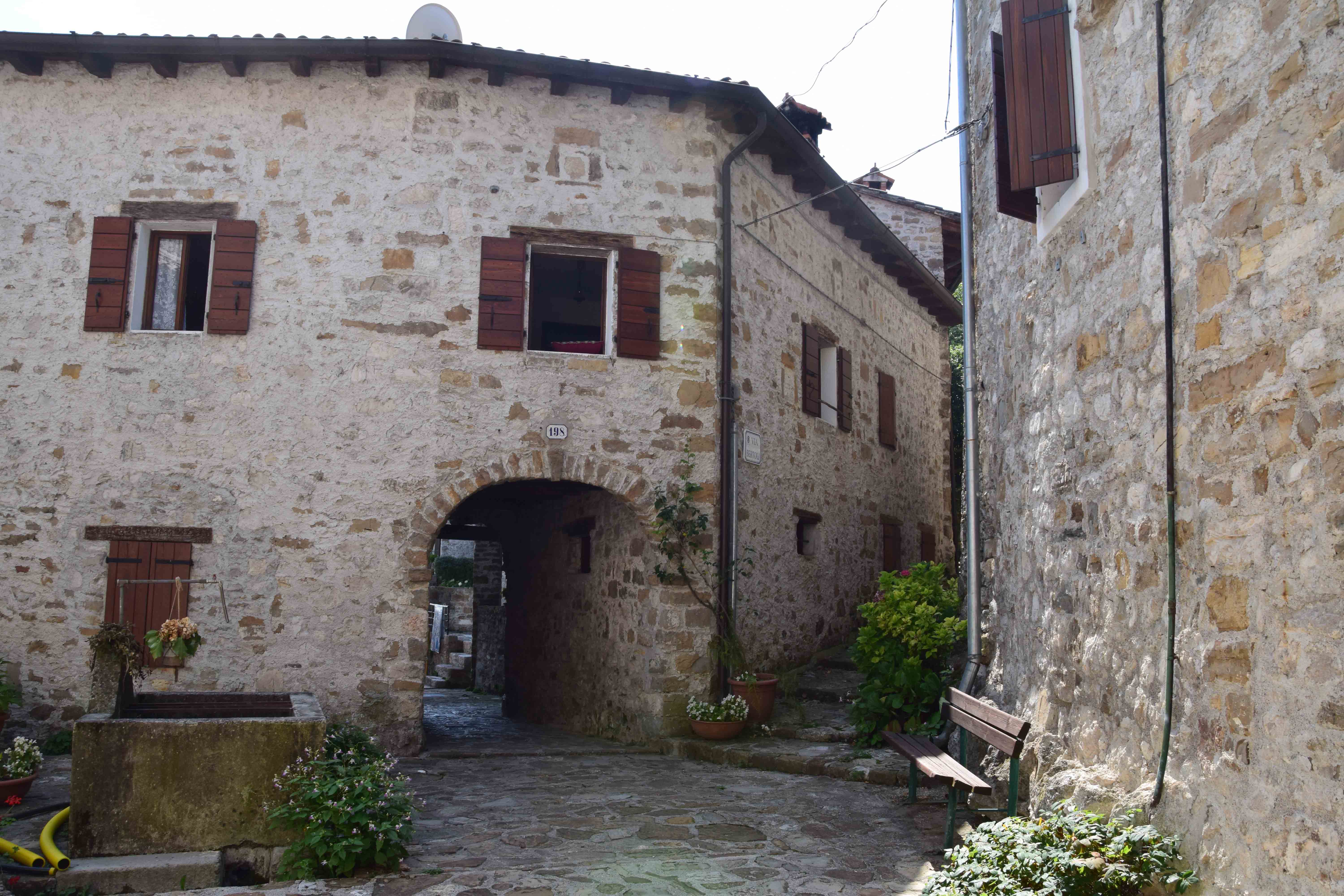
Photo 10
2.8
/3
ENTRANCE
%20(FILEminimizer).jpeg)
Ingresso
Entrance typology
TYPE:
MainACCESSIBLE:
YesTIPO:
PrincipaleHeight difference (> 2.5 cm)
PRESENT:
YesDISLEVEL:
-
TYPE:
RampUNIVOCAL CODE:
RA1RAMP:
WIDTH (CM):
150LENGTH (CM):
200SLOPE:
SLOPE (°):
4SLOPE (%):
7CORRIMANO:
PRESENT:
NoSIDE KERB:
NoNON-SLIP FINISH:
NoCOLOUR CONTRAST:
NoTACTILE-PLANTAR PATHS:
No
Threshold (< 2.5 cm)
PRESENT:
YesHEIGHT:
1Entrance door
TYPE:
Single leafOPENING:
OutdoorAUTOMATED OPENING:
NoNET DOOR CLEARANCE:
Single or sliding doorMEASURE (CM):
110DOOR AND BACK DOOR COPLANARITY (NOT ASSESSED HEIGHT DIFFERENCE UP TO 2.5 CM):
YesZERBINI/CARPETS:
PRESENTS:
NoINTERCOM/BELL:
PRESENT:
YesHEIGHT (CM):
115LOCATION:
To the left of the doorGlass doors: window decals to indicate their presence
PRESENTS:
NoCOMPARTMENT
Compartment name
TYPE:
Generic, of the structureIDENTIFIER:
V1Door
ACCESS:
NoneDimensions
ROTATION DIAMETER 140 CM:
YesPREVAILING CLEAR WIDTH:
> 75 cmPaving
TYPE:
MoreOTHER TYPOLOGY:
StoneColour contrast floors/walls
TYPE:
YesFLOOR COLOUR:
Dark greyWALL COLOUR:
WhiteSignage
TACTILE-PLANTAR PATHS:
NoTOUCH MAP:
NoINFORMATION SIGNAGE:
NoFurniture
COUNTER:
-
HEIGHT:
UniqueGROUND CLEARANCE (CM):
120EMPTY UNDER:
No
CONNECTION PATHWAYWAY
Connection
ITINERARY IDENTIFIER:
C1DA:
Generic, of the structureA:
Generic, of the structureType of route
Internal itinerary characteristics
DIMENSIONS:
PREVAILING CLEAR WIDTH:
> 75 cmPAVING:
TYPE:
MoreOTHER TYPOLOGY:
StoneCOLOUR CONTRAST FLOORS/WALLS:
FLOOR COLOUR:
DarkWALL COLOUR:
WhiteSIGNAGE:
TACTILE-PLANTAR PATHS:
NoTOUCH MAP:
NoINFORMATION SIGNAGE:
NoHEIGHT DIFFERENCE (> 2.5 CM):
PRESENT:
YesDISLEVEL:
-
TYPE:
Long staircaseUNIVOCAL CODE:
SL1LONG STAIRCASE (HIGHER THAN ONE FLOOR):
WIDTH (CM):
120CORRIMANO:
PRESENT:
YesTYPE:
Two sidesCOLOUR CONTRAST:
NoSTEP:
TYPE:
Irregular footstepsNOTES:
Scala elicoidaleTACTILE-PLANTAR PATHS:
No -
TYPE:
Elevator/elevator platform with closed compartmentUNIVOCAL CODE:
AS1ELEVATOR/ELEVATOR PLATFORM WITH CLOSED COMPARTMENT:
DOOR TYPE:
a doorNET DOOR CLEARANCE (CM):
80SPACE IN FRONT OF DOOR 140X140 MIN:
YesCABIN SIZE:
DOOR SIDE (CM):
95BLIND SIDE (CM):
130EXTERNAL BUTTON PANEL:
BRAILLE:
YesRELIEF :
YesCOLOUR CONTRAST:
NoINTERNAL BUTTON PANEL:
BRAILLE:
NoRELIEF :
YesCOLOUR CONTRAST:
NoBUZZER:
NoEMERGENCY CAMERA:
No
Glass doors: window decals to indicate their presence
PRESENTS:
NoCommon parts: no furniture with bodies protruding from the base up to a height of 210 cm
PRESENTS:
NoPresence of tactile information map of available routes and services
PRESENTS:
NoSafety in case of emergency in common areas: presence of acoustic alarm
PRESENTS:
NoSafety in case of emergency in common areas: presence of luminous alarm
PRESENTS:
NoEmergency safety in common areas: emergency light, visual escape route signs, evacuation route map
PRESENTS:
YesBATHROOM
Present
Type
Plan
NUMBER:
1VICINITY TO:
MoreOTHER TYPOLOGY:
LiftAnti-bathing
PRESENT:
YesWIDTH (CM):
150LENGTH (CM):
140EXCLUSIVE TOILET ACCESS:
NoANTI-BATHROOM DOOR:
PRESENT:
YesDOOR TYPE:
Single leafOPENING:
InsideNET DOOR CLEARANCE:
Single or sliding doorMEASURE (CM):
79ACCESSIBLE WASHBASIN ANTI-BATHROOM:
PRESENT:
NoACCESSIBLE TOILET DOOR
PRESENT:
YesDOOR TYPE:
Single leafOPENING:
InsideNET DOOR CLEARANCE:
Single or sliding doorMEASURE (CM):
80Compartment WC accessibile
WIDTH (CM):
160LENGTH (CM):
300SMOOTH ROTATION:
YesCOLOUR CONTRAST FLOORS/WALLS:
YesFLOOR COLOUR:
DarkWALL COLOUR:
Light BlueeEMERGENCY BELL:
YesGROUND CLEARANCE (CM):
110PROXIMITY TOILET BOWL:
YesMENSOLA:
NoCOAT HOOK:
NoWC BOWL
TYPE TOILET BOWL:
SuspendedWITH FRONT HOLE:
NoHEIGHT FROM GROUND WITHOUT AXLE COVER (CM):
49DISTANCE FROM REAR WALL (CM):
64BACK SUPPORT:
YesTYPE OF SUPPORT:
External boxAXLE CLEARANCE:
Right-hand sideCM:
170FRONTAL APPROACH ONLY:
NoHANDLION:
YesTYPE OF HANDLE:
Fixed, TipperFIXED HANDLE SIDE:
LeftHEIGHT LEFT SIDE (CM):
82VERTICAL:
NoFOLDING HANDLE SIDE:
RightHEIGHT RIGHT SIDE (CM):
78NOTES:
Button raggiungibile ma in posizione scomodaFLUSH BUTTON:
AccessibleNOTA:
Pulsante raggiungibile ma in posizione scomodaDOCCINO:
NoACCESSIBLE WASHBASIN TOILET
PRESENT:
YesTYPOLOGY WASHBASIN:
SuspendedGROUND CLEARANCE (CM):
84FRONT CLEARANCE (CM):
160TYPE OF TAP:
Long lever mixerMIRROR:
YesMIRROR TYPOLOGY:
AdjustableMIRROR HEIGHT FROM GROUND (CM):
100SOAP HOLDERS:
YesSOAP DISH HEIGHT (CM):
110PAPER HOLDER/DRYER:
YesPAPER HOLDER HEIGHT (CM):
140HANDLION:
YesShower
PRESENT:
NoTactile map showing the layout of sanitary facilities
PRESENTS:
NoCourtesy aids on request (shower chair, toilet seat, ...)
PRESENTS:
NoSecurity in the event of an emergency: doors with a mechanism that allows them to be opened from the outside even when locked from the inside
PRESENTS:
YesSafety in an emergency: emergency light
PRESENTS:
No3
/3
ENTRANCE
Entrance typology
TYPE:
SecondaryACCESSIBLE:
YesTIPO:
SecondarioLOCATION IN RELATION TO THE MAIN:
Side.Height difference (> 2.5 cm)
PRESENT:
YesDISLEVEL:
-
TYPE:
RampUNIVOCAL CODE:
RA2RAMP:
WIDTH (CM):
150LENGTH (CM):
100SLOPE:
SLOPE (°):
4.57SLOPE (%):
8CORRIMANO:
PRESENT:
NoSIDE KERB:
NoNON-SLIP FINISH:
NoCOLOUR CONTRAST:
NoTACTILE-PLANTAR PATHS:
No
Threshold (< 2.5 cm)
PRESENT:
YesHEIGHT:
1Entrance door
TYPE:
With two doors or with two opening elementsOPENING:
InsideAUTOMATED OPENING:
NoNET DOOR CLEARANCE:
With two doors or with two opening elementsOVERALL BORE (CM):
120MAIN DOOR (CM):
60DOOR AND BACK DOOR COPLANARITY (NOT ASSESSED HEIGHT DIFFERENCE UP TO 2.5 CM):
YesZERBINI/CARPETS:
PRESENTS:
NoINTERCOM/BELL:
PRESENT:
NoGlass doors: window decals to indicate their presence
PRESENTS:
NoCOMPARTMENT
_MOD.jpg)
Interno
Compartment name
TYPE:
Generic, of the structureIDENTIFIER:
V1Door
ACCESS:
NoneDimensions
ROTATION DIAMETER 140 CM:
YesPREVAILING CLEAR WIDTH:
> 75 cmPaving
TYPE:
MoreOTHER TYPOLOGY:
StoneColour contrast floors/walls
TYPE:
YesFLOOR COLOUR:
White, red, blackWALL COLOUR:
BeigeSignage
TACTILE-PLANTAR PATHS:
NoTOUCH MAP:
NoINFORMATION SIGNAGE:
No2.2
/3
ENTRANCE
.jpeg)
Ingresso
Entrance typology
TYPE:
MainACCESSIBLE:
NoTIPO:
PrincipaleHeight difference (> 2.5 cm)
PRESENT:
YesDISLEVEL:
-
TYPE:
Short staircase/stepUNIVOCAL CODE:
SB2SHORT STAIRCASE (LESS THAN ONE FLOOR):
WIDTH (CM):
90NUMBER OF STEPS:
1HEIGHT OF INDIVIDUAL RISER (CM):
9CORRIMANO:
PRESENT:
NoINTERMEDIATE LANDING:
NoTACTILE-PLANTAR PATHS:
No
Threshold (< 2.5 cm)
PRESENT:
No/LevelEntrance door
TYPE:
Single leafOPENING:
InsideAUTOMATED OPENING:
NoNET DOOR CLEARANCE:
Single or sliding doorMEASURE (CM):
90DOOR AND BACK DOOR COPLANARITY (NOT ASSESSED HEIGHT DIFFERENCE UP TO 2.5 CM):
NoZERBINI/CARPETS:
PRESENTS:
NoINTERCOM/BELL:
PRESENT:
NoGlass doors: window decals to indicate their presence
PRESENTS:
NoCOMPARTMENT
Compartment name
TYPE:
Generic, of the structureIDENTIFIER:
V1Door
ACCESS:
NoneDimensions
ROTATION DIAMETER 140 CM:
YesPREVAILING CLEAR WIDTH:
> 75 cmPaving
TYPE:
TilesColour contrast floors/walls
TYPE:
YesFLOOR COLOUR:
BrownWALL COLOUR:
YellowSignage
TACTILE-PLANTAR PATHS:
NoTOUCH MAP:
NoINFORMATION SIGNAGE:
NoFurniture
TABLE:
-
TYPE OF SUPPORT:
Corner legsTYPE OF PLAN:
Rectangular/SquareWIDTH (CM):
90LENGTH (CM):
90GROUND CLEARANCE (CM):
75GROUND CLEARANCE (CM):
72TOP WITH ROUNDED EDGES:
No
CHAIR:
-
Backrest
FIXED TO THE GROUND:
No
OUTDOOR AREA
.jpeg)
Tavoli e sedie
Destination of the area
AREA TYPOLOGY:
ConsumptionType
Access to the area
TYPE:
From the main door already describedHeight difference (> 2.5 cm)
PRESENT:
NoPaving
TYPE:
Concrete/porphyry coplanar blocksDimensions
ROTATION DIAMETER 140 CM:
YesPREVAILING CLEAR WIDTH:
> 75 cmFurniture
TABLE:
-
TYPE OF SUPPORT:
Corner legsTYPE OF PLAN:
Round/OvalDIAMETER (CM):
60GROUND CLEARANCE (CM):
73GROUND CLEARANCE (CM):
70TOP WITH ROUNDED EDGES:
No
CHAIR:
-
Backrest, Armrests
FIXED TO THE GROUND:
No
2.5
/3
PARKING FOR PUBLIC USE
_MOD.jpg)
Stallo di parcheggio
Public car park features
TYPE:
Outdoor uncoveredSTALL:
-
NUMBER OF STALLS:
1TYPE:
in combWIDTH (CM):
300LENGTH (CM):
490SIGNAGE:
HorizontalPAVING:
Concrete/Asphalt or coplanar stone
Connection with the footpath
HEIGHT DIFFERENCE (> 2.5 CM):
PRESENT:
No0.5
/3
PARKING FOR PUBLIC USE
.jpeg)
Stallo di parcheggio
Public car park features
TYPE:
Outdoor uncoveredSTALL:
-
NUMBER OF STALLS:
1TYPE:
In lineWIDTH (CM):
240LENGTH (CM):
440SIGNAGE:
Horizontal, VerticalPAVING:
Rough concrete/porphyry blocks, cobblestones, erba, legno